The South Riverside Racetrack
Was Located in what is now Central Riverside Park at
720 Nims Street
Wichita, Kansas

The ovoid, visible in the center of this aerial photograph, is now just a gravel sport trail / walking path but it loosely marks the location of the South Riverside Racetrack in 1902 - Google photo
The Wichita Board of Trade organized a number of events for the public celebration of Labor Day on Monday, September 1, 1902. Among those events were races on the half-mile dirt racetrack in South Riverside Park (now known as Central Riverside Park) in Wichita, Kansas. Bicycle races, pony races, and automobile races were all on the afternoon schedule. "No less than 12,000" spectators lined the racetrack. The automobile races were to be open to all comers and consist of three events. The first two races were qualifying heats with the final to be six-laps long. $10 cash was put up by the organizers to go to the winner of the 3-mile final event. The second place finisher was to receive 50 soda fountain coupons redeemable at the local Dockum-Higginson drug store.
The other scheduled events went off without a hitch on Labor Day but there was only one entrant in the automobile races. That was a 1901 Oldsmobile driven by Morris Schollenberger who, with brother George Schollenberger, had recently closed their bicycle shop at 230 North Main Street and opened an Oldsmobile dealership known as the Wichita Automobile Company at the corner of Second and Broadway Streets in Wichita. Their Oldsmobiles were the first gasoline powered automobiles to be sold in Wichita. While the race organizers pondered what to do about the lack of entries, another brother, Harry Schollenberger, offered to race his motorcycle against Morris Schollenberger's Oldsmobile. Since the motorcycle was much faster than the automobile, Harry challenged his brother to turn four laps of the racetrack faster than he could run six laps on his motorcycle. The challenge was accepted at first but then the organizers decided to have both vehicles race for eight laps instead, since there would be only one race rather than three races as had been advertized. The race began after a pace lap that led to a rather fast rolling start. The motorcycle jumped out to a big lead turning the first lap in 55 seconds compared to the automobile's 90 second initial lap. The motorcycle ran the second lap in 53 seconds while the automobile was able to post a time of 75 seconds on its second lap. The motorcycle lapped the automobile just short of the three-lap mark while the automobile was just completing its second lap. The motorcycle's time on its third lap was 50 seconds while the automobile posted a time of 70 seconds on its third lap.
By the fourth lap, it had become obvious that the motorcycle would not be able to complete six laps before the automobile completed four as had been originally proposed. The motorcycle maintained its speed through the fourth lap but started to slow on the fifth lap when the drive-belt became overheated and began to slip. The timekeeper missed the automobile's time on laps four and five but caught the auto with its best time of the afternoon on lap six with a time of 62 seconds and the seventh lap at 65 seconds. Although the motorcycle had slowed to a crawl, it was still a lap ahead of the Oldsmobile when it dropped out of the race at the beginning of the eighth lap. The automobile was able to complete the eight-lap distance and Morris Schollenberger was, therefore, declared to be the victor.
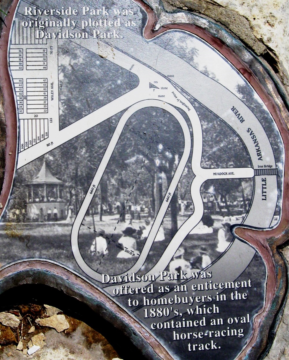
This stone trail marker is located on the inside edge of the sport trail / walking path on the east side of the trail itself where it passes by just to the east of the parking lot which is located on the far west side of the ovoid. The marker clearly depicts the location of the horse racetrack in this artist's conception of Davidson Park as it was proposed in 1887. Note that the racetrack was not depicted as an ovoid. Also note that each straightaway was depicted to have been 660 feet long while the turns at each end of the racetrack were depicted as each having a radius of 210 feet.
As late as the 1990s, overgrown landscaping shrubbery could still be seen growing around what had been the inside of the third and fourth turns (the northeast end) of where the old racetrack had been. The trees that were then growing on the race course itself, were much smaller than the older, more mature trees that were then growing throughout the rest of Central Riverside Park. The landscaping is now different from what it was in the 1990s, and no physical evidence of the South Riverside Racetrack remains.
The name was changed from Davidson Park to Riverside Park in the late 1890s. At that time, the park area north of the Little Arkansas River (north of what is shown on this map) was called North Riverside Park while the area depicted on this map was called South Riverside Park. Several years later, more park area was added (south of what is shown on this map) and that then became known as South Riverside Park so the old South Riverside Park, where the racetrack had been located, then became known as Central Riverside Park which it is still known as today. Click your mouse on the photo above to see a close-up of the map depicted on this stone marker - Connie Lawrence photo